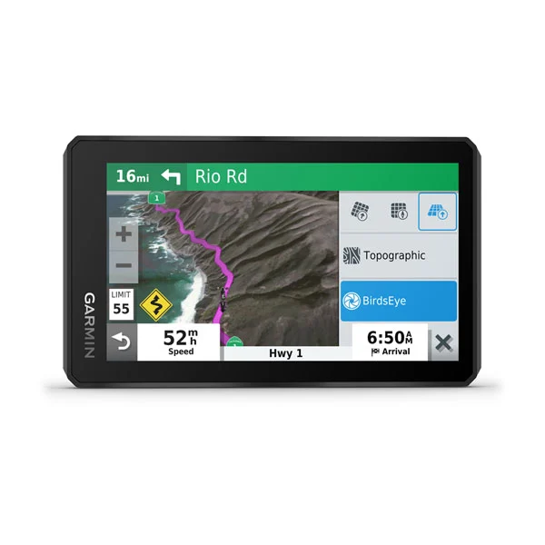
The 5.5-inch display is brighter than previous models and can be seen in any light. It’s also glove-friendly with crisp HD resolution in landscape or portrait mode.
Go confidently into every ride with a navigator that’s built to withstand all kinds of weather (IPX7) and rough rides.
With the backlight set at 100% brightness, the battery lasts up to 3.5 hours, and it can go up to 6 hours on regular settings. Or you can hard-wire to constant power for longer adventures.

You’ll have access to global BirdsEye Satellite Imagery with direct-to-device downloads via Wi-Fi® connectivity and no annual subscription.
Be ready for the ride with pre-loaded street maps of Southern Africa. Map updates included.
Adventurous riding is encouraged with preloaded off-road topographic maps.
Quickly toggle between on-road maps, topographic maps and BirdsEye Satellite Imagery, so you can always have the perfect map for your ride.
Turn straightforward rides into twisting, gnarly adventures by selecting your road preferences.
Record your route by using the track recorder, and save or share it for future adventures.
Easily send GPX files from your phone to your zūmo XT, or share GPX files with fellow riders by using the Garmin Drive™ app.

View TripAdvisor traveller ratings for hotels, restaurants and attractions along your route or near your destination.
zūmo XT includes iOverlander™ POIs and millions of popular places, thanks to Foursquare®.
Get alerts for hazards along your route, such as upcoming sharp curves, speed changes and more. You’ll also be notified about upcoming safety cameras3.
Easily manage4 and review routes, tracks and waypoints across your navigator, smartphone and computer by using the Garmin Explore™ app.
Get spoken turn-by-turn directions through your connected helmet or headset. They guide like a friend, using street names, store names and recognizable landmarks.
Stream music from your smartphone through the zūmo XT navigator, or play MP3 files stored on the navigator — all to your connected helmet or headset.

With Bluetooth® technology, you can make hands-free5 calls. When paired with the Garmin Drive app on your phone, you can view smart notifications right on your zūmo display.
Access2 real-time traffic and weather, share routes with other riders, and get phone notifications via the Garmin Drive app.
Pair zūmo XT with a compatible inReach satellite communicator1 for two-way messaging, location sharing and, in case of emergencies, SOS capabilities.
If an incident occurs, a text message with location information is automatically sent to your predetermined contact2.
Built-in Wi-Fi4 connectivity makes it easy to keep your maps and software up to date without using a computer. Onscreen cues show when new updates are available.

| General | |
| Dimension | WxHxD: 14.8 x 8.8 x 2.4 cm |
| Weight | 262 g |
| Water rating | IPX7 |
| Display Type | Multi-touch, glass, high brightness HD colour TFT with white backlight |
| Display Size | 12.1 x 6.8 cm; 5.5-inch diag (13.9 cm) |
| Display Resolution | 1280 x 720 pixels |
| Dual-Orientation Display | Yes |
| Handlebar mount (up to 1″) | Yes |
| Drop rating | MIL-STD-810 |
| Battery type | Rechargeable lithium-ion |
| Battery life | Up to 6 hours (up to 3.5 hours at 100% backlight) |
| Maps & memory | |
| Preloaded street maps | Yes |
| Data cards | microSD™ card (not included) |
| 3D Terrain | Yes |
| Internal storage | 16 GB |
| Ability to add maps | Yes |
| Storage and Power Capacity | yes (256 GB max microSD™ card) |
| Includes map updates | Yes |
| Downloadable Satellite Imagery | Yes (BirdsEye) |
| BirdsEye Direct Satellite Imagery | Yes |
| TOPO map support | Yes |
| Sensors | |
| GPS | Yes |
| Galileo | Yes |
| Outdoor recreation | |
| Point-to-point navigation | Yes |
| PRELOADED TOPOGRAPHIC MAPS | Yes |
| Navigate-a-track navigation | Yes |
| Camera features | |
| Backup camera compatible | yes (BC 40) |
| Navigation features | |
| Garmin Real Directions™ landmark guidance | Yes |
| Millions of Foursquare® points of interest | Yes |
| TripAdvisor® Traveller Ratings | Yes |
| Route shaping through preferred cities/streets | Yes |
| Traffic Updates | Yes (with Garmin Drive™ app) |
| Lane assist with junction view (displays junction signs) | Yes |
| Bluetooth® calling | yes (works with BLUETOOTH-compatible helmet, headset or smartphone. BLE capable) |
| Speed limit indicator (displays speed limit for most major roads) | Yes |
| Driver alerts for sharp curves, school zones, red light and speed camera warnings and more | Yes |
| Advanced features | |
| Smart notifications via app | Yes |
| Wi-Fi® map and software updates | Yes |
| Access to live services via app | Yes |
| Motorcycle features | |
| Control music and media from smartphone or MP3 player | Yes |
| Sunlight readable and weather resistant | Yes |
| GARMIN ADVENTUROUS ROUTING™ | Yes |
| Rider alert warnings for sharp curves, speed cameras and more | Yes |
| Planned & dynamic fuel stops | Yes |
| Motorcycle or powersports specific points of interest for cycle repair services, dealers and more | Yes |
| Helmet law notifications | Yes |
| Elevation profile | Yes |
| Round trip routing | Yes |
| Service History Log | Yes |
| Track support | Yes |
| Custom map support | Yes |
| Wireless ANT+® technology | Yes |
| Adventure features | |
| Pair with compatible inReach® devices | Yes |
| Pair with Garmin PowerSwitch™ digital switch box | Yes |
| Compatible with Group Ride Tracker (6”, 8” and 10”) | Yes |
| Track recorder (breadcrumbs) | Yes |
| iOverlander™ points of interest | Yes |
| ACSI, Campercontact and Trailer’s PARK | Yes |
| Birdseye Satellite Imagery (download via Wi-Fi) | Yes |
| Glove-friendly touchscreen | Yes |
| Group Ride Radio | |
| Radio Frequency Band | Compatible with Group Ride Tracker |
| Group Ride Tracking | Compatible with Group Ride Tracker |
| Group Ride update rate | 5 seconds |
| Radio transmitted canned messages | Compatible with Group Ride Tracker |