
Advanced Chart DetailDetailed charts help the mariner guide their boat in and out of port with confidence. |
 |
Depth Range ShadingDisplays high-resolution Depth Range Shading for up to 10 depth ranges so you can view your designated target depth. |
 |
Detailed ContoursBlueChart g2 HD features 1-foot contours that provide a more accurate depiction of bottom structure for improved fishing charts and enhanced detail in swamps, canals and port plans. |
 |
MarinerEye ViewProvides a 3-D representation of the ocean floor as seen from below the waterline. |
 |
FishEye ViewProvides a 3-D representation of the surrounding area both above and below the waterline. |
 |
High-resolution Satellite ImageryHigh-resolution satellite imagery with navigational charts overlaid gives you a realistic view of your surroundings so you can navigate with a clear moving-chart representation of your boat’s position. It’s our most realistic charting display in a chartplotter |
 |
Aerial PhotographyCrystal clear aerial photography shows exceptional detail of many ports, harbors and marinas and is ideal when entering unfamiliar ports. |
 |
|
|
| Feature | g3 HD | g3 Vision HD |
|---|---|---|
| 1′ HD Contours | • | • |
| Depth Range Shading | • | • |
| Shallow Water Shading | • | • |
| Navigational aids, spot soundings, depth contours, tides and currents and detailed harbors and marinas | • | • |
| Auto Guidance | • | |
| 3-D Views (MarinerEye & FishEye) | • | |
| High Resolution Satellite Imagery | • | |
| Aerial Photography | • | |
| Detailed coastal roads up to 5 miles inland | • |
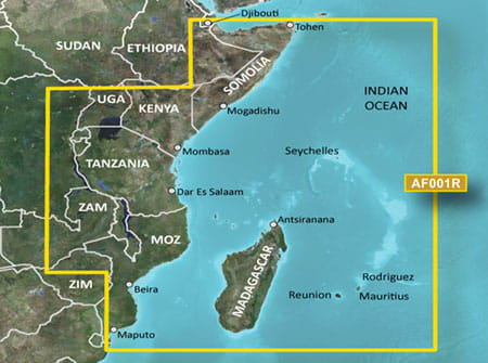
Coverage of the east coast of Africa, Madagascar and the major lakes of Eastern Africa. Coverage is from the Gulf of Tadjoura to the Bay of Maputo and includes Zanzibar and Pemba Islands, Madagascar, Mauritius, Reunion, the Comoros and the Seychelles. Major ports include Djibouti, Dji., Mogadishu, Som., Mombasa, Ken., Dar es Salaam, Tan. and Maputo, Moz. Lake coverage includes Lakes Albert, Edward, Victoria, Kivu, Tanganyika, Malawi, Cahora Bassa and Kariba.
